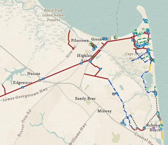
Trail Map: Cape Henlopen Region
Created by
Eric J.S.
Posted
June 9, 2022
Last updated
June 9, 2022
Category
Cartography
Tools Used
ArcGIS OnlineArcGIS ProArcGIS Field MapsArcGIS Dashboards
Summary
The beaches in Delaware are a very popular tourist attraction in the summer. Many visitors choose to drive and park in the lot closest to the sand, but there is another option. Lewes, Rehoboth, and Cape Henlopen State Park are all connected with an impressive multi-use trail network designed with bikes in mind.
Bike Trail Development
More bike infrastructure and public transit options would be a great help in the fight against climate change as they would reduce our oil dependence. Not to mention, they would help us avoid skyrocketing gas prices as consumers.
Thankfully, additional bike trails are planned in the Cape Henlopen area, including a paved multi-use trail connecting Lewes and Georgetown. This trail will be entirely segregated from car traffic by following the defunct railroad along Route 9. Read more about these upcoming trails with the resources below.
- Development Phases of the Georgetown-Lewes Trail via Delaware Greenways
- Work on Trail Along Route 9 Underway via The Cape Gazette
- Cape Henlopen State Park Trail Plan via Delaware.gov
Other Maps
Of course, my map is not the only trail map of this area. However, none of the options that I found focused specifically on bike infrastructure while including all of Lewes, Rehoboth, and Cape Henlopen State Park. Here are the ones that I found:
- Play Outside Map via Delaware.gov-- Messy and includes planned trails that don't exist yet.
- Georgetown Lewes Rail Trail via Trailforks-- Pretty close, but still missing some segments as well as facilities.
- Lewes-Rehoboth Regional Map PDF via DE State Parks-- The best I could find, but it's a PDF and it's missing a lot of detail.
Data Collection
A portion of the facility locations (small items such as bike repair stations) were collected on location with ArcGIS Field Maps. I created smart forms for each type of facility, which allowed me to collect additional data that is not displayed on the map. For example, I recorded an approximate number of parking spaces in each lot as well as usage restrictions on each trail section.
ESRI charges additional money for a “tracking license” which allows Field Maps users to track and record their location. This would allow for easy collection of trail data, but I don't have the budget nor do I have the time to ride/walk every trail. Instead, I used ArcGIS Pro to import official trail data from the State of Delaware.
https://opendata.firstmap.delaware.gov/datasets/delaware::delaware-trails-and-pathways-2-0/about
For facility locations that I did not collect in the field (large items such as parking lots) and some trails that were not included with the dataset, I used satellite imagery to digitize them.