Automated: Landsat Imagery Mosaic
Created by
Eric J.S.
Posted
April 12, 2022
Last updated
April 12, 2022
Category
Automation
Tools Used
ArcGIS ProPython
Summary
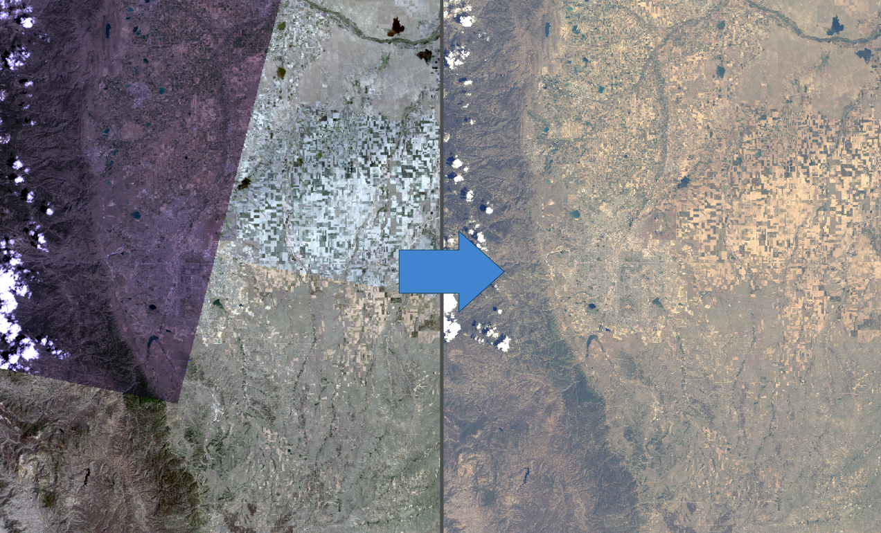
In my attempt to gather Landsat imagery for another project, the place I wanted to focus on happened to be at the edge of 3 different scene captures. I wanted to create a Mosaic Dataset in ArcGIS Pro to merge these 3 scenes into one seamless mosaic so the area I want to analyze is completely covered by imagery.
Workflow
I acquired my Landsat scenes from USGS Earth Explorer. I used Collection 2 Level 2 imagery which is processed to a higher degree than Collection 1 or Level 1. Each scene includes TIF image bands and metadata files with MTL in their filenames.
First, define the options and which operations should be executed. It is assumed a geodatabase exists.
import arcpy

# environment settings
# set the geodatabase where the script will create items
arcpy.env.workspace = r"D:\path\to\geodatabase.gdb"
# overwrite items in the workspace with items created by this script
# if this is false, an error will occur when an item already exists
arcpy.env.overwriteOutput = True

# script settings

# show output of each geoprocessing tool
# https://pro.arcgis.com/en/pro-app/2.8/arcpy/geoprocessing_and_python/using-tools-in-python.htm
verboseOutput = True

# imagery type
# must be one of the following:
#   LANDSAT_6BANDS - Create a 6-band mosaic dataset using the Landsat 5 and 7 wavelength ranges from the TM and ETM+ sensors.
#   LANDSAT_8BANDS - Create an 8-band mosaic dataset using the LANDSAT 8 wavelength ranges.
# based off product_definition values:
#   https://pro.arcgis.com/en/pro-app/latest/tool-reference/data-management/create-mosaic-dataset.htm
# other types could be supported by adding logic to find and organize other file naming structures
imageryType = "LANDSAT_8BANDS"

# select which operations to perform
createRasterComposites = True
createMosaicDataset = True
addRastersToMosaic = True
buildFootprints = True
buildSeamlines = True

# text to append to raster composites
compositeText = "_composite"

# full path to directory where the images are stored
imagesFolder = r"D:\path\to\Landsat\scenes"

# name of the mosaic to be edited
mosaicName = "Landsat8Mosaic"
Find and catalog the Landsat scenes in the directory based on the MTL text files.
# scan a directory for MTL text files and TIF files
# return a list of dictionaries with the scene name, MTL file, list of TIFs, and associated raster composite
# scenes can be in subfolders, but related MTL and TIF files must be in the same directory
def find_landsat_scenes(directory):
    # scene dictionary will have pairs (key: value)
    # (name: scene name)
    # (mtl: path to mtl file)
    # (images: [list of TIF files])
    # (composite: path to composite raster)
    landsatScenes = []
    # iterate through the MTL text files
    for mtl in glob.glob(directory + r"\**\*_MTL.txt", recursive=True):
        splitPath = mtl.split("\\")
        # get the scene name from the MTL file
        sceneName = splitPath[-1][:-8]
        print("found scene: " + sceneName)
        # get the path to the containing folder
        sceneDir = "\\".join(splitPath[:-1])
        tifList = []
        # find all TIFs in that containing folder
        allTifs = glob.glob(sceneDir + r"\*.TIF")
        # find any related TIFs and add them to the image list
        for tif in allTifs:
            if sceneName in tif:
                tifList.append(tif)
        # check if the composite raster already exists for this scene
        compName = sceneName + compositeText
        compositePath = None
        if arcpy.Exists(compName):
            # if it exists, set it to the full path
            compositePath = arcpy.env.workspace + "\\" + compName
        # if related TIFs were found, add the scene to the list
        if len(tifList) > 0:
            landsatScenes.append(
                {
                    "name": sceneName,
                    "mtl": mtl,
                    "images": tifList,
                    "composite": compositePath
                }
            )
    return landsatScenes
It is possible to add each MTL text file directly into the Mosaic Dataset; ArcGIS Pro will recognize and add the appropriate image bands automatically. But, through trial and error I found that creating a raster composite of each scene and adding that to the mosaic provides a much more consistent color scheme across scenes from different dates.
    # index all MTL and related files
    sceneList = find_landsat_scenes(imagesFolder)
    # exit if no scenes (MTLs) were found
    if len(sceneList) == 0:
        sys.exit("No scenes found.")
    if createRasterComposites:
        print("creating composite rasters")
        for scene in sceneList:
            compositeName = scene["name"] + compositeText
            print("create composite: " + compositeName)
            # run the geoprocessing tool to create each composite raster
            result = arcpy.CompositeBands_management(scene["mtl"], compositeName)
            if verboseOutput: print(result)
            # set the index to the composite in the scene list
            scene["composite"] = arcpy.env.workspace + "\\" + compositeName
Create the empty Mosaic Dataset using the spatial reference from the first image in the catalog. This assumes each scene uses the same spatial reference or is at least in the same vicinity. However, this script could be easily modified to accept a user-defined spatial reference.
    if createMosaicDataset:
        print("creating mosaic dataset: " + mosaicName)
        # creating a mosaic dataset requires a spatial reference
        # this tool assumes all rasters are in the same area
        # and simply gets the spatial reference of the first TIF found
        describeRaster = arcpy.Describe(sceneList[0]["images"][0])
        # set the spatial reference of the raster
        rasterSpatialRef = describeRaster.spatialReference
        # run the geoprocessing tool
        result = arcpy.CreateMosaicDataset_management(
            arcpy.env.workspace,
            mosaicName,
            rasterSpatialRef,
            product_definition=imageryType
        )
        if verboseOutput: print(result)
Add the recently created raster composites to the Mosaic Dataset.
    if addRastersToMosaic:
        print("add rasters to mosaic: " + mosaicName)
        # build a list of composite rasters
        compList = []
        for scene in sceneList:
            if scene["composite"]:
                compList.append(scene["composite"])
        # exit if no composites are found
        if len(compList) == 0:
            sys.exit("No raster composites found.")
        # run the geoprocessing tool
        result = arcpy.AddRastersToMosaicDataset_management(
            mosaicName,
            "Raster Dataset",
            compList,
            update_overviews="UPDATE_OVERVIEWS",
            build_pyramids="BUILD_PYRAMIDS",
            calculate_statistics="CALCULATE_STATISTICS",
            duplicate_items_action="OVERWRITE_DUPLICATES"
        )
        if verboseOutput: print(result)
Build footprints and seamlines for the mosaic. Footprints will determine which areas are actually covered by image data and seamlines will help images to overlap more naturally.
if buildFootprints:
print("building footprints for: " + mosaicName)
result = arcpy.BuildFootprints_management(mosaicName)
if verboseOutput: print(result)
if buildSeamlines:
print("building seamlines for: " + mosaicName)
result = arcpy.BuildSeamlines_management(mosaicName)
if verboseOutput: print(result)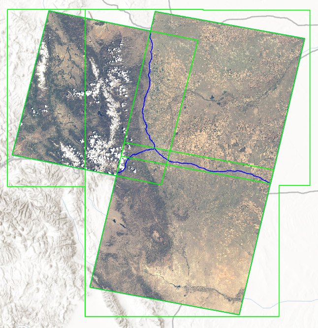 Green lines are footprints. Blue are seamlines.
This entire script is hosted on GitHub.